

A developing Bay of Bengal system is expected to intensify into a deep depression, putting urban waterlogging, vulnerable embankments and emergency preparedness back under scrutiny
BHUBANESWAR: Odisha is entering another critical weather window, but the immediate concern is not simply how much rain will fall. The larger question is how effectively the state can absorb, drain and respond to the water expected over the coming days.
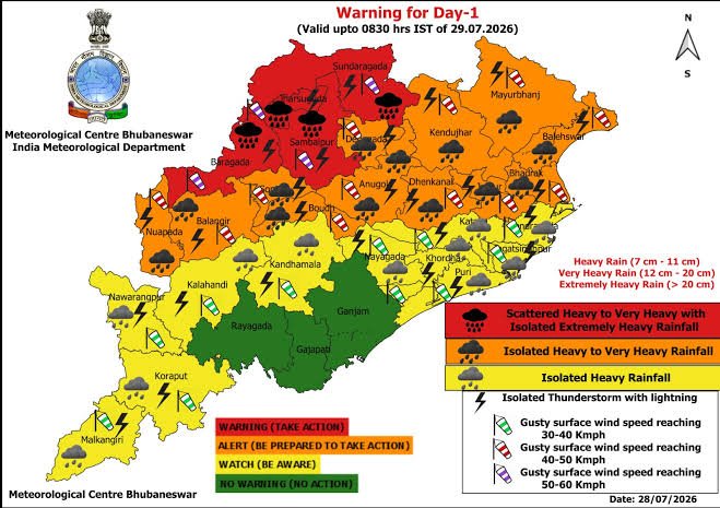
The India Meteorological Department’s Bhubaneswar centre, in its September 20 warning, has forecast very heavy rain for Odisha on September 22, followed by extremely heavy rainfall on September 23 and 24. Very heavy rain is also forecast for September 25 and 26. Thunderstorm and lightning activity remains part of the warning picture as well.
The weather system behind the forecast developed as a low-pressure area over the Bay of Bengal. According to the latest reporting based on the IMD assessment, the system is expected to strengthen into a depression and subsequently a deep depression before moving towards the Odisha–north Andhra coast. The IMD has not, however, issued a cyclone forecast for the system at this stage.
That distinction matters because the immediate preparedness requirement is already clear even without a cyclone warning.
For Odisha, heavy rainfall quickly becomes a test of multiple systems operating simultaneously: urban drainage, road connectivity, river and canal monitoring, embankment protection, power supply, emergency communications and the ability of district administrations to reach vulnerable communities.
The pressure will be particularly visible in low-lying urban pockets. When drainage capacity is exceeded, even rainfall that does not produce a major river flood can disrupt traffic, affect homes and businesses and isolate important roads.
The state’s disaster-management machinery is designed to deal with precisely such situations. The Special Relief Organisation lists prevention, preparedness, response, relief and rehabilitation among its responsibilities and coordinates with district administrations during natural calamities.
But preparedness is not measured only by the existence of a control room.
The coming rainfall will put practical questions on the ground: Are vulnerable drainage points clear? Are pumping arrangements functional? Are flood-prone roads identified? Are embankment watch teams ready? Are sandbags and other emergency materials available at vulnerable locations? Can local administrations respond before water cuts off connectivity?
Odisha’s Water Resources Department disaster-management guidance specifically calls for continuous watch over vulnerable embankments, attention to locations where breaches occurred previously, advance availability of flood-contingency materials and intensified monitoring when water levels rise.
This makes embankment surveillance another important part of the next few days.
The weather challenge is also arriving at a time when Odisha is approaching a busy festive period. Any combination of intense rain, waterlogging, damaged roads, lightning and local flooding could create additional pressure on traffic management, public gatherings and emergency services.
The state has built a reputation around early-warning systems and disaster preparedness. The Odisha government recently highlighted its early-warning and “Zero Casualty” approach at the BRICS Disaster Risk Reduction Working Group meeting in Puri.
The present spell therefore offers another real-world test of that preparedness model.
The most important issue is not whether every locality can remain completely free from waterlogging during extreme rainfall. Rather, it is whether vulnerable locations are identified in advance, warnings reach people quickly, critical infrastructure remains accessible and emergency response begins before a local weather problem develops into a wider disruption.
The next several days will provide that test.
For the public, the message is equally straightforward: the forecast remains subject to change as the weather system evolves, and district-level warnings should take priority over broad statewide assumptions.
For the administration, the immediate task is preparation.
For Odisha, the next 96 hours will show how effectively its drainage networks, embankment monitoring and disaster-response arrangements can convert advance warning into action.
GTNS | BHUBANESWAR